The Harmony Bible Map follows the chronology presented by Thomas and Gundry, section by section. We have grouped these in five phases and also shown the regions in the time of Jesus. Now you can follow Jesus and gain a better understanding of his travels. Authur Blessitt calculates that Jesus walked over 41,000 miles in his lifetime.
Instructions: (video tutorial)
- Click the “menu icon” in the upper left corner of the map to show/hide the legend. There you can turn on/off each phase to see more or fewer details.
- Zoom in using your mouse, touch pad or +/- icon in the bottom left corner of the map.
- The push pin denotes a “specific town or location” mentioned in the section;
- The square denotes a “region”.
- Click the square in the top right corner of the map to open the larger map in a new window.
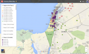 The square ■ map marker signifies an unspecified location or a region but a likely location given the biblical event, and those surrounding it. The map pin designates a specific location (town, lake, river, temple) noted in the passage and the site as supported by tradition or archaeological evidence.
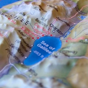 Relief Map:
We highly recommend that you purchase this relief map of the Holy Land to help them understand the distances, cultural regions that correspond to Jesus’ travels, miracles, and teachings recorded throughout the Gospels. kinesthetic learners will get a much better sense of the terrain when using this relief map.
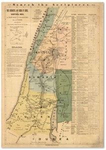
Wall Map:
We also recommend that you print a 11×17 color copy of this map for every member of your small group. The map was authored and distributed by the Rev. A.P. Stout A.P. Stout, an American minister and the author of Journeys and Deeds of Jesus (shown below), the Travels of Jesus, and “The Chronology of Christ’s Life.“. He was a contemporary of A.T. Robertson (whose chronological sequence we follow in the Harmony of the Gospels) and Lt. Claude Conder who had completed a thorough survey of Palestine and incorporated into his map.
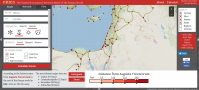 ORBIS:
The Stanford Geospatial Network Model of the Roman World. A reconstructed map showing seasons, time, and cost associated with various modes of travel among 632 sites across Roman Empire c. 200AD/CE.
Google Earth KML Files
If you use Google Earth (different from Google Maps) you’ll find these KML files of places mentioned in The Gospels very helpful.